Friday, March 3, 2023

Westward to Westwood

“Go West, young man, go West. There is health in the country, and room away from our crowds of idlers and imbeciles.”  
 – Quoted in 1833 by U.S. Congressman Josiah Bushnell Grinnell as direct advice from American author and editor Horace Greeley. The origin of the phrase remains unproven.

“Go west” was also a fitting message during Winnipeg’s rapid growth prior to World War I. Real estate agents jumped at the chance to profit from the boom, when crowds of newcomers flocked to the city.
There were few, if any, cities in Canada in 1914 that could match the dynamic changes that had taken place in Winnipeg. In only forty years Winnipeg grew from a small fur-trading post with less than two thousand inhabitants to a sprawling metropolis one hundred times that size [… and] by 1914 Winnipeg’s population and industry were spilling over into surrounding municipalities. [1]
There were several land speculators eager to promote new suburbs far from downtown. Among these proposed developments were areas we know well: St. Charles and Westwood.

Articles and advertisements gushed with effusive praise, promoting these areas as upscale and beautiful. Smart investors would be foolish not to act quickly to secure a piece of paradise so full of promise.

Winnipeg Tribune, December 1906 [2]

James A. Halsted, Esq. (1841–1914) in 1906 [3]

One particular real estate mogul eager to sell lots in Westwood was J. A. Halsted. He was actually a private banker in Durham, Wingham and other nearby towns, and mayor of Mount Forest, Ontario. He saw that there was money to be made out west, and established the Halsted Land Company. Its offices were in the top floor of the McIntyre Block in Winnipeg, a massive building that housed a wide range of businesses, including several real estate agencies.

The McIntyre Block, 416 Main Street, Winnipeg, circa 1908 [4]

 The Halsted Land Company promoted its west Winnipeg property aggressively between 1906 and 1911. It named the new neighbourhood Halsted (sometimes Halstead) Park in its copious newspaper advertisements, which were often larger and more numerous than those of competing real estate firms. Investors were urged to get in on the ground floor. 

Winnipeg Free Press, September 1906 [5]

The proposed lot map shown in the above ad is helpful. Halsted Park was the property between Portage Avenue and the Assiniboine River, and included Sumach, Seaton, River (now Raquette), Queen (now Best) and Whittier (now Bedson) streets. 

A 1961 map shows Halstead Park (Whittier to Sumach streets). This slice of real estate was not formally named Halstead Park (the early promoters’ term), but was in the middle of the Westwood suburb (which is officially the area between Portage Avenue and the Assiniboine River, and between the two golf courses.) [6]

Back then, the area was essentially undeveloped, “beautifully wooded with oak, poplar and elm, and lies high and dry, sloping gently to the river.” Buyers need not worry about the spring floods that could threaten downtown and low-lying areas of the city. Other 1906 sales features included regular trolley car service on Portage Avenue, local ferry service just east of Sumach Street over the Assiniboine River (moved to St. Charles Street in 1908), nearby churches and schools (including the just-opened St. Charles Catholic School), and proximity to “the Gentlemen’s Country Club Grounds” (i.e., St. Charles Country Club) which opened in 1904.

The street car service was an important factor in developing Winnipeg suburbs. 

“Winnipeg Electric Company 1428 operating the Suburban Rapid Transit Company route to Headingley in the winter of 1927.” [7]

By the end of October 1906 the Halsted Land Co. claimed to have sold 250 building lots since September 8, but cautioned that present prices would hold for one more week. Potential investors were constantly warned to act quickly before prices increased and lots sold out.

Winnipeg Free Press, November 1906 [8]

Halsted was keen to market this desirable property. It had a lot going for it, and he knew how to pitch it. Creative full-page advertisements could not be missed.

Winnipeg Tribune, November 1906 [9]

As a salesman, Halsted was an enthusiastic, but verbose, copywriter. The long-winded full-page ad above predicted that Halsted Park would become a choice locale: “This is no windy puff, but a bare statement of fact about a piece of land possessing natural advantages that are on a par with the finest property in or around Winnipeg.” Further, “The soil will bear comparison with the finest virgin prairie in the Province, and the timber need scarcely be interfered with beyond a judicious thinning when it comes to the beautification of the home.” With a little work and little cost, “any part of it can be quickly transformed into an umbrageous and secluded haven of rest, a paradise of peace far removed from the dust and din, the mingled splendor and squalor of a City that throbs with new life every day from its centre to its circumference.”

A peculiar ad referenced Theodore Roosevelt and featured simplified spelling and smart investment. It introduced two real estate firms (Neely & Rodgers and the Central Real Estate Co.) alongside the Halsted Land Co. The ad below ran once.

Winnipeg Free Press, November 1906 [10]

The “Who Can Doubt?” ad published four days later was more traditional. It promoted the usual features of “the most desirable property on the market,” adding that Winnipeg “has a future before it similar to that of the largest cities of the United States.” The message was clear: “There can not be found any safe or better investment than Real Estate in a great and growing city.” Investors were again advised to move quickly while prices held.

Winnipeg Tribune, November 1906 [11]

In the next ad, P.O. LeClair & Company (also at 712 McIntyre Block), was listed as the real estate agent. Notable on this over-written ad is that Halsted is now spelled Halstead, but only in the headline.

Winnipeg Free Press, December 1906 [12]


The top of the $$$$ ad promoted real estate investment generally, then said of Halstead Park that “This property sells on its own merits, and requires no boosting.” They then added the boosting, including, “we predict that within three years it will be built up with suburban homes, and those who wish to escape the discomforts of living in the congested limits of the city should secure some of this property without delay.” 

In mid-December 1906 the Winnipeg Tribune featured a map of the city indexing and illustrating its many sub-divisions. A supplementary map shows where Halsted Park was located (river lots 100 and 101). St. Charles Street (river lot 95), is identified by the RC Church notation. The Buchanan Nurseries (later Royaumont in 1922, then Glendale Golf and Country Club in 1946) would have been between St. Charles Street and Halsted Park. Phoenix Park and Dudley Park are unfamiliar names, but may have been other real estate promotions like Halsted Park. The confusing “St. Chas P.O.” and “St. Chas School” on Portage Avenue north of “Country Club” mark the St. James municipal hall across from Kirkfield Park School.

Winnipeg Tribune, December 1906 [13]

One day later, the Tribune published a glowing article entitled “Halsted Land Co.” that was essentially another advertisement for the company. The text noted, “The sales of Halsted Park have been unrivalled in the history of Winnipeg and are increasing week by week as the merits of the property become known.” It ended the endorsement with, “Halsted Park is a suburb that will occupy a foremost position in the history of Greater Winnipeg, which history is now in the making.”

Winnipeg Tribune, December 1906 [14]

Ad frequency dipped between 1906 and 1910, when Tully & Tully emerged as real estate agents for Halstead Park. They appear to prefer the Halstead spelling, although later ads revert to Halsted. Their ad (below) notes the aforementioned features of the property, along with the “go west” message, noting, “Commencing at Crescentwood, the great residential district, west, is the Agricultural College, the Manitoba University, the golf links, the government rifle range (soon to be moved farther west still), St. Charles Country Club, Kirkfield Park (with the finest race track in the Dominion), St. Charles Village, the new rifle range, where there will shortly be stationed 3,000 men (this means better car service), and Headingly, the terminus of the street cars at present. Does not this show a great line of development; does it not echo and re-echo the truth—‘the west is king?’ ”

Another paragraph in the ad suggests the neighbourhood remained undeveloped. “HALSTEAD PARK is one of the next properties to develop into settlement. Watch it grow in population. To-day only two houses, but they are new.”

Winnipeg Free Press, May 1910 [15]

A subsequent 1910 ad, after four years of promotion, suggests little had actually been built in Halstead Park, but that it would “be all built on shortly.” Readers thinking it was stark prairie would be reassured by the nearby infrastructure noted: the village of St. Charles, the Country Club to the east, and the village of Charston (Charleswood) across the river. Perhaps their sales had been to land speculators, and not to individuals planning to build their dream homes.

Winnipeg Free Press, May 1910 [16]

Tully & Tully advertised frequently in May of 1910, urging investors to act quickly before prices rose again.

Winnipeg Free Press, May 1910 [17]

The ad below claimed owners had already commenced building, but did not specify how many homes were underway. (Perhaps Tully got a call from Halsted; note the spelling of Halsted Park.)

Winnipeg Free Press, May 1910 [18]

By June of 1910 prices had risen from $65–$85 to $70–$90 per lot. Tully & Tully now boasted that two houses had been built and four more were to begin construction by July 1. 

Winnipeg Free Press, June 1910 [19]

In 1911, Alexander Spenard, another realtor in the McIntyre Block, was selling Halsted lots. A brief want ad noted, “Halsted Park, St. Charles, has made many friends during the last twelve months, and won the confidence of two thousand investors. The owner of this sub-division offers half-a-dozen only, beautifully treed river lots, size 50x250, at $15 per foot. The quick investor will double his money inside of one year. Cars pass property every hour now, and a twenty-minute service is assured by next week. So get in front and await developments.” [20]

Spenard listed a Halstead Park home for sale in 1913. The home was only two years old and the property included a stable and large garden. “Owner will sacrifice.” Oh oh.

Winnipeg Free Press, February 1913 [21]

Halstead Park was only one of Winnipeg’s new suburbs being promoted to investors during an exciting boom. It appeared to have the features and promise a realtor dreams of. But the sales campaigns dwindled by 1913, when Winnipeg’s real estate market collapsed. A year later, World War I halted immigration, and commercial activity (including land sales) declined. “The ‘continuous joy-ride’ was over as Winnipeg entered a new era.” [22]

August 1914 was the end of an era for 73-year-old J. A. Halsted, too. He passed away in Toronto from pneumonia [23], leaving an estate of $308,000. [24]

J. A. Halsted home in Mount Forest, Ontario. If this was the kind of neighbourhood he envisioned for Halsted Park, it was not to be. [25]

Sadly, Halstead Park never did materialize as promised. The area today, the core of Westwood, does not feature stately old historic and unique homes from the early 1900s. It instead exemplifies baby boom sprawl, with modest, middle-class homes built in the 1950s to 1970s. Contrary to the early hype, it is no rival to Tuxedo or Crescentwood. 

1962 newspaper ad for Westwood Lands Ltd. [25]


Westwood in 1961 (notations added). [27] St. Charles is on the far horizon, just beyond Halstead Park. 

Sources

  1. Alan F. J. Artibise, Winnipeg: A Social History of Urban Growth 1874-1914 (Montreal and London McGill–Queen’s University Press, 1975), pp. 172–173.
  2. “St. Charles,” Winnipeg Tribune. 15 Dec. 1906, pp. 17–18.
  3. “Views of Mount Forest,” J. T. Skales and G. F. Chapman. Mount Forest, Ontario. 1906. https://archive.org/details/viewsofmountfore00skal/page/n1/mode/1up?view=theater 
  4.  “Pictorial Souvenir of Winnipeg,” Manitoba Historical Society, http://www.mhs.mb.ca/docs/sites/mcintyreblock.shtml 
  5. “Halsted Park: One of Winnipeg’s Most Beautiful Suburban Properties,” Winnipeg Free Press. 8 Sept. 1906, p. 11. 
  6. “Street Map of The City of Winnipeg Manitoba (1961),” https://www.flickr.com/photos/manitobamaps/3922733505/in/photolist-6YD31i-564Ryi-xtupTm-ybwEcS-ybwDDN-6YCMN4-6JwxRJ-6Jxi1f-6JxwPQ-7kqjLZ-6JwJeL-6JwdeA-6YnAnv-6Jx4JA-6JvBk1-4gsTKY-UoXwZj-8Y1T5g-xWkFjR-x79DUB-5x7P4C-2m1TMB8-xnRmbw-wrMn8K-6wBoaG-wjtGGx 
  7.  “Transit Service to Headingley, Manitoba,” Winnipeg Transit photo. University of Manitoba archives, https://home.cc.umanitoba.ca/~wyatt/alltime/pics/winnipeg-headingly.html 
  8. “Halsted Park has advanced in price 25%,” Winnipeg Free Press. 2 Nov. 1906, p. 3. 
  9. “A Millionaire’s Counsel,” Winnipeg Tribune. 3 Nov. 1906, p. 11. 
  10. “Theodore Roosevelt Advocates Simplified Spelling and Judicious Investment of Money,” Winnipeg Free Press, 6 Nov. 1906, p. 3. 
  11. “Who Can Doubt?” Winnipeg Tribune, 10 Nov. 1906, p. 6.
  12. “$$$$$$$$$$$$ Halstead Park,” Winnipeg Free Press, 6 Dec. 1906, p. 49.
  13. “McPhillips Bros’ Outline Plan of the City of Winnipeg and Suburbs Manitoba,” Winnipeg Tribune, 14 Dec. 1906, p. 15. 
  14. “Halsted Land Co.,” Winnipeg Tribune, 15 Dec. 1906, p. 18. 
  15. “Halstead Park,” Winnipeg Free Press, 21 May 1910, p. 16. 
  16. “Halstead Park,” Winnipeg Free Press, 23 May 1910, p. 3. 
  17. “Halstead Park,” Winnipeg Free Press, 26 May 1910, p. 3. 
  18. “Halstead Park: A Great Investment,” Winnipeg Free Press, 28 May 1910, p. 20. 
  19. Halsted Park,” Winnipeg Free Press, 4 June 1910, p. 3. 
  20. “Halstead Park, St. Charles,” Winnipeg Free Press, 19 May 1911, p. 22. 
  21. “West-End Suburban Home at Halstead Park, St. Charles,” Winnipeg Free Press, 11 Feb. 1913, p. 3. 
  22. Alan F. J. Artibise, Winnipeg: A Social History of Urban Growth 1874-1914 (Montreal and London McGill–Queen’s University Press, 1975), p. 283. 
  23. “News Around Town,” Durham Chronicle, 3 Sept. 1914, p. 1. 
  24. Stephen Edward Thorning, Hayseed Capitalists: Private Bankers in Ontario (McMaster University, 1994), p. 427. 
  25. “Views of Mount Forest,” J. T. Skales and G. F. Chapman. Mount Forest, Ontario. 1906. https://archive.org/details/viewsofmountfore00skal/page/n1/mode/1up?view=theater 
  26. Westwood Lands Ltd. advertisement, Winnipeg Free Press, 8 September, 1962, p. 13.
  27. Bill Rose, Westwood (looking west) 1961, Winnipeg Free Press photo archives, https://store.winnipegfreepress.com/photostore/photo-details/296243/#order 


Saturday, November 12, 2022

You're in the army now

On June 21, 1940, the National Resources Mobilization Act was passed in Canada. The NRMA required eligible able-bodied men between 18 and 45 to register and be ready to undergo 30 days of basic training in anticipation of home defence needs. According to the Canadian Encyclopedia, the Act

represented the government's response to the public clamour for a more effective Canadian war effort that arose in the wake of the stunning German victories in Belgium and France. The Act enabled the government to requisition the property and services of Canadians for home defence. An earlier promise made by PM Mackenzie King in 1939 not to introduce conscription for overseas service was honoured, but it was reversed in August 1942 following the national plebiscite of April 1942. The amended NRMA permitted the sending of conscripts overseas in addition to the existing regular volunteer forces. The NRMA was important politically as it attested to the government's determination to intensify the war effort. It tended to appease the conscriptionists without antagonizing the anti-conscriptionists. In military affairs the Act created a duality in Canada's military that was to last until the war's end. It also resulted in the training of a large body of men for military duty. From 1940 to 1944 close to 60,000 NRMA soldiers ("zombies") volunteered for general service, and several thousand more were sent to the front after the use of conscripts for overseas service actually began late in 1944.  [1]

The Winnipeg Free Press announced that under the Act "Canada will have clothed herself in totalitarian powers in order that we may resist to the uttermost an invasion which, fantastic though it seemed a week or a month ago, is now a grim prospect, too real to be ignored. A six clause bill, adopted on second reading, without one dissenting vote, places all persons and their property at the disposal of the government for purposes of home defence. Thus parliament moved, swiftly and unitedly, to meet the direst peril this country ever has known."  [2]

The Winnipeg Tribune declared the idea was splendid, stating, "The one and immediate tangible thing is the announcement that a national registration of Canadian manpower will be launched without delay. That is all to the good." The editorial stated that "Canada is more than ready for an all-out war effort" but noted that the NRMA did not impose conscription of manpower for service overseas; only those who volunteer to do so would be sent abroad.  [3]


Winnipeg Free Press, June 19, 1940, p. 20  [4]

A proclamation in newspapers across the country began with the introduction: "Calling out men of certain age classes for medical examination, and if fit, to undergo military training for a period of 30 days within Canada, or the territorial waters thereof."
Pilot Mound Sentinel, September 27, 1940, p. 4.  [5]

Having turned 21 on May 31, 1940, Dad was among the first age group required to register and undertake 30 days of basic training. The Pilot Mound Sentinel explained to readers that the first step was to complete a questionnaire.

Pilot Mound Sentinel, August 2, 1940, p. 4.  [6]

The newspaper published a sample of the questionnaire itself, so that registrants could be prepared and the process could be conducted easily and swiftly.
Pilot Mound Sentinel, August 9, 1940, p. 4.  [7]

An advertisement gave further details.
Pilot Mound Sentinel, August 9, 1940, p. 2.  [8]

Murray Fraser submitted two impressive references attesting to his suitability and good character.

August 5, 1940. G. W. Brisbin (1881-1957), came to Pilot Mound from Ontario at age 17. He was very involved in the community, and served as a school trustee, town councillor, and mayor of Pilot Mound. You could not find a more upstanding citizen to write a reference for you.

A second reference from Pilot Mound's high school principal, Axel Vopnfjord (1902-1993), later a University of Manitoba professor, confirmed Brisbin's praise of Murray Fraser.

Principal Vopnfjord wrote that Murray Fraser was quiet, gentlemanly, and trustworthy. Absolutely true.
 
Within weeks of registering, Murray Fraser was called up in October of 1940 for training with the Royal Winnipeg Rifles for Course 1 ending November 7, 1940. N.P.A.M. Training Centre No. 101 was in Brandon.
 `
It is interesting to note that Murray Fraser expressed no preference for either the navy, army, or air force.

But on side 2, Lt. Mooney wrote that Murray Fraser was "Willing to join R.C.A.F."

Murray listed his occupation as "Farmer," which might have warranted a delay for harvest season, but it appears he did not postpone this training. On October 9, he was in the first group of Canadian men who reported at the 39 Training Centres set up across the country.  [9] 

Registrants were required to carry a wallet card at all times, should it be demanded by the proper authorities. Those refusing to register could face fines or imprisonment.


Murray Fraser registered on the 19th of August, 1940 and kept this card in his wallet throughout the war. 

A CP story reported on November 7 that the 25,000 men in this first group had completed their 30 days of military training. 
Officials of the department of national defence which trained the men and the department of national war service which called them from their homes expressed satisfaction at the results of Canada's first step in compulsory military service in the present war. While the majority of the men who underwent training will return to civilian life, quite a number are remaining in the army or have gone to the Royal Canadian Air Force.  [10] 
A few weeks later, in December of 1940, Dad began training at the Henry Avenue vocational centre in Winnipeg under the War Emergency Training Program. Available courses included Aviation, Radio, Telegraphy, International Code, Machine Shop Practice, Forging, Welding, Sheet Metal, Auto Mechanics, Airplane Engine Fitting, Drafting, and Cabinet Making. He completed his training in Winnipeg on April 15, 1941. 

A mere ten days later, Murray was in the air force, receiving further training in St. Thomas, Ontario. He studied Air Frame Mechanics (18 weeks) and Advanced Metal Work (6 weeks), finishing as a Leading Aircraftman. In November of 1941 he reported to No. 6 Repair Depot, Trenton, where he served the bulk of his service. On or about March 18, 1945 he went overseas to Squadron 426 in Linton-on-Ouse. and was finally discharged February 7, 1946.

Trenton, 1941  [11]

Sources

  1. Nandor Fred Dreisziger, "National Resources Mobilization Act," The Canadian Encyclopedia, December 16, 2013
  2. Grant Dexter, "Full Power: Drastic Measures Rushed By Ottawa," Winnipeg Free Press, June 19, 1940, p. 1.
  3. "Splendid--Provided It Really Means Business," Winnipeg Tribune, June 19, 1940, p. 6.
  4. "Text of Bill," Winnipeg Free Press, June 19, 1940, p. 20.
  5. "Proclamation," Pilot Mound Sentinel, September 27, 1940, p. 4.
  6. "National Registation," Pilot Mound Sentinel, August 2, 1940, p. 4.
  7. Pilot Mound Sentinel, August 9, 1940, p. 4.
  8. Pilot Mound Sentinel, August 9, 1940, p. 2.
  9. C.P. Stacey, Six Years of War -- The Army in Canada, Britain and the Pacific; Chapter 4: Recruiting and Training in Canada
  10. "25,000 Complete 30 Days' Training," Winnipeg Free Press, November 7, 1940, p. 6.
  11. "Training of Ground Crew Trades," 419 Squadron RCAF 1941 to 1945  


Monday, August 1, 2022

Mapmaker, mapmaker

While the house we grew up in was literally and solidly cemented in place in 1915, its address actually changed a few times: 

  • River lot 95. 
  • 86 St. Charles Street. 
  • 400 St. Charles Street. 
  • Corner of St. Charles and Taché Avenue. 
  • Corner of St. Charles and Sansome Avenue.

It is intriguing to examine old maps to see these developments.

We think of St. Charles as a small village, but the Parish of St. Charles (established in 1855) was actually very large, and extended on both sides of the Assiniboine River from Headingley to the Parish of St. Boniface border in present-day River Heights.

Excerpt of an 1871 map of Manitoba. Established in 1870, Manitoba was a mere 130 miles (210 km) wide and 110 miles (177 km) tall and called the Postage Stamp Province.  [1]
(See Sources below for links to full size maps on Flickr.)

On maps like the one above, the St. Charles Church (first built in 1866) is a good landmark for pinpointing St. Charles Street. Post offices are also noted here, but the scale cannot identify whether the St. Charles Post Office was at the top of the street at Portage Avenue (the "Great Highway"), or elsewhere.

Winnipeg was a city of rivers (Assiniboine, Red, and Seine). The three rivers made mapping river lots a challenge, especially when they intersected. Long narrow lots allowed access to the river and houses there were closer together. This system was used in Quebec and brought west by French fur traders.

1874 "Plan of River Lots in the Parishes of St. Charles and Headingley"  [2]
The border between Headingley and St. Charles is the present-day east edge of John Blumberg Golf Course. St. Charles Parish extended to the city limits at St. James Street. On the south side of the river, it met up with St. Boniface Parish in River Heights. Tuxedo Park was built on St. Charles lots 5 through 24. According to local historian Dan Furlan, Charleswood was part of St. Charles Parish until 1913.  [3]
(Click on image for a larger view.)  

Excerpt from "McPhillips Plan of the Municipality of Assiniboia Manitoba (1907)"  [4]

This map clearly indicates that St. Charles Street was essentially River Lot 95 in the Parish of St. Charles. Again, the R.C. Church notation (red emphasis added) confirms this, as does an early handwritten "Ferry" at the bottom of the street. 

The ferry was originally located further east at a shallow buffalo crossing called "The Passage." It ran from 1870 to 1908 connecting "Ferry Road" (now Rouge Road) on the north side to Berkley Street, N. on the south side of the river. 

In 1908 (two years after St. Charles RC school opened), the ferry was relocated to St. Charles Street, which had deeper water and was more convenient for the school/convent, manse, and church. The ferry remained in operation until 1959, when the Perimeter Highway bridge was built just west of St. Charles Street.

"McPhillips Outline Map of Winnipeg & Vicinity (1909)"  [5]

The 1909 McPhillips map identifies St. Charles Street at Lot 95, with the church and the ferry location there. Another ferry is still noted to the east, likely its original Passage location. 

The St. Charles Ferry, c. 1909. The ferry appears to be heading south to Xavier Drive in Charleswood.  [6] 

By 1912, a boom year in the city, Winnipeg maps were getting more detailed — and colourful! It was also a notable year in St. Charles. It got a water pump, one block north of where our 1915 home would be built.

Winnipeg Free Press, December 28, 1912. (The Provencher Avenue in St. Charles was renamed Lepine Avenue in 1963.)

"West Sheet of Chataway's Map of Greater Winnipeg (1912)"  [7]

The excerpt above features the St. Charles Country Club. The name is confusing enough, as it is not the golf course at St. Charles Street only 5 km away. That was the Royaumont, now Glendale Golf & Country Club. Although the St. Charles Country Club was in the Parish of the same name, confusion was only compounded when it was proposed that the street on its west border be named St. Charles Boulevard. That name didn't last, and neither did the actual street. As in many suburban neighbourhoods, the area was redesigned with curving bays that replaced straight roads.

Also noted in the map above is the Kirkfield Park Race Track, where speedy horses, motorcycles, and automobiles thrilled crowds. This is also the site of the St. Charles airdrome of the 1920s. Swallowed by suburban housing, this site is largely forgotten, but it was an important airport before Stevenson Field, our current airport site, was established in May 1928.

The "Old Rifle Range" is the site of the Grace Hospital, which opened in 1967. South of the hospital on Sturgeon Creek sits Grant's Old Mill, a replica of the unsuccessful 1829 mill built by Métis leader Cuthbert Grant (1793-1854). This historical site opened in 1975.

There is no hint of the old Kirkfield Park oval raceway and St. Charles airdrome today. Who knew that Quail Ridge was in the infield?  [Apple Maps, annotated]

"Chataway's Map of Greater Winnipeg Enlarged & Revised Edition (1917)"  [8]

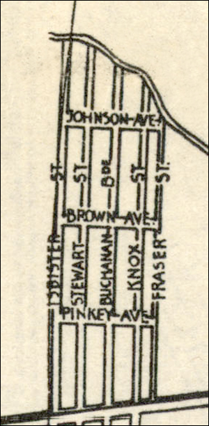
The excerpt above, north of Saskatchewan Avenue up to Sturgeon Creek, contains a curious little neighbourhood that includes "Fraser St." and "Pinkey Ave." Perhaps this enclave was planned but never built, because even the St. Charles streets we recognize (Isbister, Stewart, Buchanan and Knox) do not extend this far north. This area past Saskatchewan Avenue remains undeveloped even now.

"Stovel's map of Winnipeg, including St. Boniface and surrounding suburbs," 1917 [9] 

Another map from 1917 and another curiosity (above). Stovel's map also shows St. Charles Boulevard next to St. Charles Country Club, as well as St. Charles Street. It seems the two existed and confused people for several years.

But this map also includes an intriguing historical tidbit. Even in this low resolution excerpt, it clearly identifies St. Charles Post Office where our 1915 house is located, and not at Portage Avenue at all. This adds credibility, if not proof, to the tale that a post office was operated out of the front den of that house. In our own lifetimes, we can recall that mail was picked up from Schulting's corner store at Portage Avenue, then from banks of locked boxes on the street (near the water pump, I think), before Canada Post finally provided home delivery in 1964.

The existence of "St. Charles Boulevard" is mysterious. While the street adjacent to St. Charles Country Club simply disappeared altogether at some point, the intent to have a so-named boulevard re-surfaced in 1962. Again, residents protested the absurd duplication.

Winnipeg Free Press, April 4, 1962

A year later, the City of Winnipeg recognized the confusion created by "certain streets that were a duplication of or similar to other streets in the Metropolitan Area" and announced that By-law No. 369 would make changes effective as of June 15, 1963. St. Charles Blvd. was renamed Banting Drive, and 20 other street names in the RM of Assiniboia were also changed.

Winnipeg Tribune, April 6, 1963

As the city expanded, the confusion did, too. St. Charles was no longer a distant village. Among the street name changes were cross-streets in the neighbourhood that had identical names to major avenues in St. Boniface, like Provencher (renamed Lepine), and Tache (renamed Sansome Avenue). Likewise, Langevin Street was renamed Gagnon Street.  

"Street Map of The City of Winnipeg Manitoba (1961)"  [10]

The problem of duplicated street names is evident even in this small excerpt from the 1961 map. Notice the Ferry Road across from St. Charles. This is likely the former Xavier Drive (later Cass Street), where the historic Caron House sits.

This map still lists the Ferry Road in Westwood, where the St. Charles ferry operated until 1908. It was eventually renamed Rouge Road. The third and remaining Ferry Road in Winnipeg still exists in St. James. The ferry is commemorated by a mural at 1874 Portage Avenue. [12]

Aside from some new cross-street names and more housing that filled in empty lots and fields, St. Charles remains much as we remember it. Neighbouring areas like Crestview and Westwood, however, were redeveloped with curving streets and bays.

A 1964 rendering from Winnipeg's Planning Division proposed formal parklands at the Perimeter Highway and Assiniboine River. A lovely thought, but the area remained largely untouched.

"Park Beside a Major Highway Bridge," 1964  [12]
The house shown between the picnic area and trailer park was that of Vic Mager. Another great old 2-1/2-storey brick farmhouse, it was torn down decades ago. The picnic area has long been used for garden lots. 

One last curiosity:

"Winnipeg Bed Rock Geology (1983)," Surveys and Mapping Branch, Department of Energy, Mines and Resources  [13]

Ignore the  heavy green dashed lines. A close look at this map of our old neighbourhood reveals two tributaries of the Assiniboine River. One extends through Glendale Golf Course. The other one is more familiar to those of us who played on the river bank and knew the trench that filled with water in the spring. This ditch ran past the trailer park, and to the pile of rocks in the field just west of our house at Gagnon and Sansome. From there it headed east, where it might have gone underground, nourishing Lairds' gardens and extending through the golf course once more almost to Portage Avenue.

Google maps confirm that this tributary is no longer evident. The only remaining clue: the odd little pump house. It may have been built when proper sewers were installed, but perhaps it affected the creek at that spot, too.

The tiny pump house between St. Charles and Gagnon streets (view looking north from Sansome Ave.)


Sources (retrieved August 1, 2022)

N.B.: Maps are from the extensive Manitoba Historical Maps collection on Flickr at https://www.flickr.com/photos/manitobamaps 

  1. "Map of the Province of Manitoba (1871)," https://www.flickr.com/photos/manitobamaps/2230280043
  2. "Plan of river lots in the parishes of St. Charles and Headingley, Province of Manitoba," https://www.flickr.com/photos/lac-bac/50743273603/in/photolist-2kj1xnD-2kj1yUr-2kj5iv8- 
  3. Dan Furlan, "Charleswood's Historic River Lots," https://www.youtube.com/watch?v=Iyt1hvg-whs  
  4. "McPhillips Plan of the Municipality of Assiniboia Manitoba (1907)," University of Manitoba Archives & Special Collections (Margaret Pugh Collection), https://www.flickr.com/photos/manitobamaps/3116088796/in/photolist-5KmLCU-6BAfe6-2nrvFW7
  5. "McPhillips Outline Map of Winnipeg & Vicinity (1909)," https://www.flickr.com/photos/manitobamaps/3762255790/in/album-72157622868092934 
  6. The Rob McInnis Postcard Collection, Winnipeg Public Library, http://pastforward.winnipeg.ca/digital/collection/robmcinnes 
  7. "West Sheet of Chataway's Map of Greater Winnipeg (1912)," https://www.flickr.com/photos/manitobamaps/2201273363/in/photolist-4mA6nS-4mw6T2-6JKm12
  8. "Chataway's Map of Greater Winnipeg Enlarged & Revised Edition (1917)," https://www.flickr.com/photos/manitobamaps/3002928816/in/photolist-5zmN7L-4nux4k-73tgVf-5sSxTb-zYDmdA 
  9. "Stovel's map of Winnipeg, including St. Boniface and surrounding suburbs," https://www.flickr.com/photos/normanbleventhalmapcenter/13983658560/in/photolist-niFUvo 
  10. "Street Map of The City of Winnipeg Manitoba (1961)," https://www.flickr.com/photos/manitobamaps/3922733505/in/photolist-6YD31i-564Ryi-xtupTm-ybwEcS-ybwDDN-6YCMN4-6JwxRJ-6Jxi1f-6JxwPQ-7kqjLZ-6JwJeL-6JwdeA-6YnAnv-6Jx4JA-6JvBk1-4gsTKY-UoXwZj-8Y1T5g-xWkFjR-x79DUB-5x7P4C-2m1TMB8-xnRmbw-wrMn8K-6wBoaG-wjtGGx
  11. The Murals of Winnipeg, http://www.themuralsofwinnipeg.com/Mpages/SingleMuralPage.php?action=gotomural&muralid=278
  12. "Park Beside a Major Highway Bridge," 1964, https://www.flickr.com/photos/manitobamaps/2653949657/in/album-72157603347076165 
  13. "Winnipeg Bed Rock Geology (1983)," Surveys and Mapping Branch, Department of Energy, Mines and Resources, https://www.flickr.com/photos/manitobamaps/4052631423/in/photolist-7b7N8z-7bbjwL-7aypec-xg3M2U-7aCBsm-wjMpbq-wjP1Gc-ow4nec